Alternative I-49 Bypass Proposals

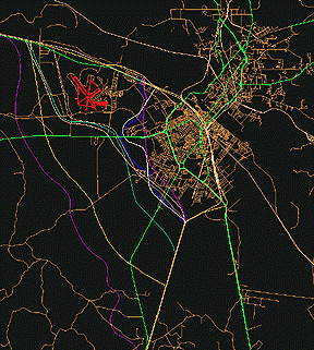
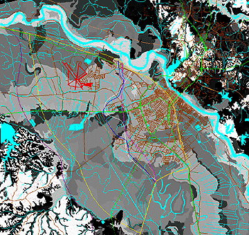
Interstate bypass alternatives

Twelve Graduate students at Louisiana State University used various (individual) methods to select alternative by-pass routes for Interstate 49.

Scoring points were awarded (or subtracted) based on a Geographic "surface" that was placed under each students road alternative.   

The student with the best score, based on the least number of subsurface points (divided by the total linear feet of each road),  won the competition.  

The student bypass alternatives are shown in Purple, Dark Yellow, Dark Green, Dark Blue, and Violet.  Existing secondary roads are shown in Brown, and major arterial roads are seen as Light Green.


The point "scoring" surface 

The alternative Interstate by-pass solutions are placed over a "point scoring" surface.

Darker color land areas are awarded more points than the lighter colored areas.  Darker areas are wetter soils with high shrinking and swelling characteristics.  Aqua colored areas are lakes and streams.

The number of acres in each point category are divided by the overall length of the Interstate by-pass for each alternative.  The three students with the least point scores were considered the "best" possible solutions.

 
 Legend:  Color code, land condition, and point score.
Color Code
Land or Water Condition Description
Score
Aqua
Area is perennial water (usually lakes streams and canals).
50 points
Black
Depth to water table is at (or near) the land surface.
40 points
D. Gray
Water table is 5+ feet and/or the soil conditions are poor for construction
30 points
Gray
Some construction limitations, but can be overcome with moderate expense.
20 points
Lt. Gray
Slight construction limitations, but can be overcome easily.
10 points
White
Very few construction limitations
 1 point

Return to EARTHUSE Homepage 

All contents copyright (C) 1992-1999,  D. Fehler,  All rights reserved.