Using the tiger.census.gov
server to locate the Paul Charles Construction Company in McGregor, Texas
76657
As an example: These
are the "actual readings" (from the GPS unit) while standing at the front
door of Paul Charles Construction Company:
31 Degrees 27.249 Minutes
-97 Degrees 22.643 Minutes
Because of the differences between hardware (and/or software)
you must convert the Degrees, Minutes, and Decimal Minutes used by the
GPS units, to Decimal Degrees used by the tiger.census server. (refer
to your GPS user manual)
Conversion Example:
Degrees, Minutes and Hundredths of Minutes <to> Decimal
Degrees.
Reference the tiger map server:
http://tiger.census.gov/cgi-bin/mapbrowse-tbl
Go to the server (above) and change the "fields" as described
(below):
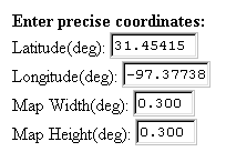
| Replace the default lat/lon position numbers with the
new location coordinates (in the fields to the right).
As a beginning point, use 0.300 for the map width and
height. |
 |
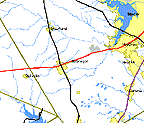 |
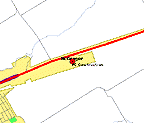
The map (that will be served to you) is of McGregor,
Texas.
A small town just West of Waco, Texas (At the Intersection
of Hwy's 84 and 317). |
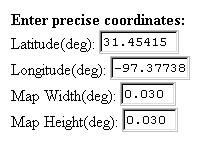 |
For a more detailed view of the area, simply change the
Map Width and Map Height, to 0.030 (degrees).
Map Scale is approximately: 1:27259 |
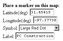
| Use the "place a marker option" adding a Large Red Dot
marker (or other) to precisely locate PC Construction.
Type in an appropriate label
(shown right). |
 |
| The "served map image" contains a Large Red Dot at the
front door of Paul Charles Construction Company.
(All map images are reduced to conserve file space) |
 |
Review GPS Basics
Return to EARTHUSE Homepage
All contents copyright
(C) 1993-1999, D. Fehler All rights reserved.
|