Background information
| Photographic example
| Return to EARTHUSE Homepage
 |
Five Steps to taking your own
3D Stereo Pictures |
 |
|
|
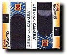
1] Create
the stereo camera. Use white glue to attach two "single use" cameras together,
bottom to bottom. Two rubber bands are used to clamp the cameras together
overnight. Establish and "mark" the cameras left and right.
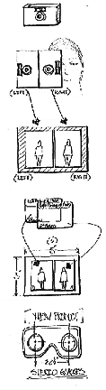
2] Take the stereo pictures.
Hold the two cameras such that the right hand holds the right camera in
an "overhand position" with the right finger on the shutter release. The
left hand is positioned in an "underneath position" with the left finger
on the shutter release. Pictures are taken with the cameras in the portrait
orientation. Remember to keep the left and right camera orientation.
This will facilitate step 4.
3] Process the stereo film.
The processing is exactly the same as normal processing. Ask for "wallet
size" prints. Wallet size is more convenient for the magnification
of my stereo viewer.
4] Assemble the stereo pairs.
Use a "glue stick" or "double sided" clear tape to attach the left and
right images to a 3 by 5 index card. It is not necessary to use
the index card, but it makes the transport, quick alignment, and viewing
much more convenient.
5] Purchase, or create the
stereo viewing glasses. I have always used the glasses for airphoto terrain
analysis. (Available from Air Photo Supply Co. in New York). These
glasses are expensive and not appropriate for every situation. |
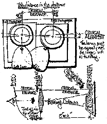 |
Where do I get the special glasses?
I recommend using two large magnifying lenses!
Two magnifying lenses are a bit difficult to manage, but
with practice stereo viewing is quite easy. Initially, try focusing one
eye-at-a-time..., then let the two images "converge" together! |
Link and References:
-
Riffel, Paul A., Reading Maps, an introduction to
maps using color stereo photographs, Hubbard Scientific, Northbrook, Illinois.
ISBN 0-8331-1300-3
-
Way, Douglas S., Terrain Analysis: A Guide to Site
Selection Using Aerial Photographic Interpretation, Stroudsburgh, PA, Dowden,
Hutchison, and Ross, Inc. ISBN 0-87933-004-X
-
Keifer, Ralph W., Classroom 3-D Projection of Landform
Photography, Photogrammetric Engineering and Remote Sensing, Vol.43,
No.3, March 1977, pp.293-297.
-
Nealey, L. David, Remote Sensing Education in the United
States, Proceedings of the American Society of Photogrammetry, 42nd
Annual Meeting, Feb. 1976.
Top of Document
Return to EARTHUSE
Homepage
All
contents copyright (C) 1996-1998, D. Fehler All rights reserved.
|