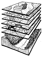
Introduction The quality and quantity of natural resources is directly affected by the impacts of human activity (as well as natural processes). Natural systems are complex, interdependent, and often dynamic earth resources that constitute the organization of what is considered the natural environment. Natural systems often represent what is regarded as beautiful as well as functional and necessary. There are resources and natural systems that can sustain intensive use, and others that are ephemeral and fragile, and easily damaged with casual interaction. To encourage resource protection the recommended environmental inventory of natural resources is segregated into three basic, but distinct categories: physical, biological and cultural. Physical resources include soils, rocks, petroleum, water and other non living elements. Biological resources include forests, plants, animals, and other living organisms (including humans). Cultural resources include transportation, recreation, utilities, health, and cultural preservation efforts. The social (or cultural) resources category contains those human activities that are in direct competition for the use (location/allocation) of the physical and biological resources. The theoritical premise is that natural resource systems can co-exist effectively with human activities given the acknowledgment of the existence of these resources and effective implementation of GIS methodologies.
The Scope of Environmental Problems Individual (local) areas cannot affect environmental solutions in isolation. Natural systems extend beyond municipal boundaries and are being modified, controlled, and very often obliterated. Cost appears to be the single inhibiting constraint for local forms of government to avoid using GIS technology. The history of land development has followed a strategy of individual land owners proposing land use activities without an overall understanding of the environmental effect. In years past the natural systems were of such magnitude to absorb land changes without drastic disruption, however, the density of the population forever changed the ability to convert land at the disgression of individuals. The "work in opposition strategies" of the 1960's has
produced two polarized viewpoints regarding the
Probable environmental solutions in the next century will evolve from local forms of government utilizing large regional data bases containing vast amounts of detailed and up to date information regarding both natural and human systems. Each community will use a regional scale set of "in common" information to make land use decisions for the individual community. Communities will have the ability to test other community(s) decisions to determine positive or negative environmental impacts. The greater environmental good (or harm) can be debated within and throughout the local and regional community. In the past GIS technologies were used by only affluent users and the case presented was often "one sided" in favor of the GIS user and at the expense of the opposition. The technique often created an air of resentment for both the user and, indirectly, Geographic Information Systems. The recommended solution to this predicament is the availability of both the GIS technology and accurate information (data) for all interested parties. The discussion and debate will then revolve around relevant environmental issues exclusively.
Return to EARTHUSE Homepage All contents copyright (C) 1993-1999, D. Fehler All rights reserved |