Homepage | Background
| Development Criteria |
On-Site Sewerage Permit
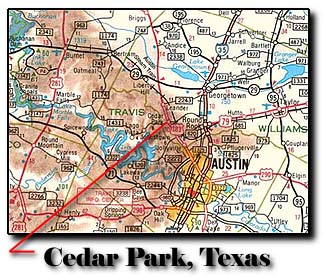
| The City of Cedar Park is in the beautiful
Texas Hill Country. Cedar Park is located about 10 miles West of Round
Rock, TX, North of Austin, TX, and just East of the Northern most part
of Lake Travis. To find Cedar Park..., look for the intersection of FM
1431 and US 183 in the center of the Regional Map. The image is a
small "portion" of the Official Texas Department of Public Safety Highway
Map. The area shown is approximately seventy miles (East to West).
Today's mapping specialist can visually determine the location of "land
surface features" quickly and easily by using high resolution multi-spectural
satellites. |
|
| Until recently..., the bulk of Community
Planning (and mapping) was on "paper" maps. Paper is useful,
but the necessity to "print" multiple copies, and the need for constant
updating had made"digital mapping" more popular. Map makers can use
"historical" area maps, incorporate existing "paper" and "digital" maps,
and then create maps of "proposed land uses" and land use "strategies"
for local goverment and private use.
There are several hundred active Satellites orbiting the
Earth. Some of the Satellite's on board sensors are for Imaging the Earth.
That is... taking "pictures" of the Earth's surface and then relaying the
Images to Ground Stations where the Satellite Images are enhanced and prepared
for use by Remote Sensing Specialists.
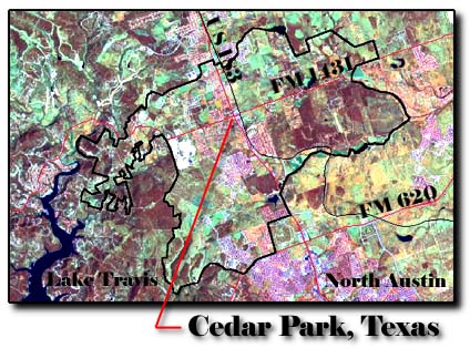 |
The image of Cedar Park as seen
from space (left) is a computer enhanced image that is "reformated" and
"coordinated" with the Latitude and Longitude coordinates provided by the
U.S.G.S, 7.5 minute Quad Maps. The process of "rectifying"
the satellite image gives the image useful "location" Global Position Satellite
(GPS) coordinates.
One can literally draw with "map accuracy" on a satellite
image that was taken 600 miles in space. |
|
All contents copyright (C)
1993-1998, D. Fehler All
rights reserved.
|