|
It is the geographic coordinate system that distinctly separates GIS from other data modeling systems. The ability to distinguish one location from all other locations on the surface of the earth, while delineating what is physically contained within that area is the rationale for using a Geographic Information System. A map projection is a system of lines on a planar surface that represents a corresponding referencing system or datum. A datum is a surveying or referencing system used as a basis for calculating and/or measuring geographic locations. The cartesian coordinate system is used to visualize the relationship of two dimensional points positioned in mathematical space. GIS coordinates represent earth ground locations in spherical space. There are numerous coordinate types with elegant and unfamiliar sounding names such as: Albers Conical Equal-Area Projection Lambert Confromal Conic State Plane Transverse Mercator Polyconic Universal Transverse Mercator Clark 1866. Both Universal Transverse Mercator and latitude/longitude projections are used by United States Geological Survey. These two map projections will provide the necessary beginning experience to comprehend any other projections (no matter the country or region). Generally speaking, any good GIS system will easily interchange the mathematically complex map projections one with another. Thinking in "GIS terms" one imagines the application of
a huge uniform grid applied mathematically to the surface of the earth,
and will reference precisely any geographic point on that surface. The
UTM projection allows one to think of the world as a flat surface, or,
enough of the earth's surface to accomplish most projects under fifty thousand
acres. In the 1991 Gulf War, troops, vehicles, airplanes, and guided missiles
were directed to their intended destinations using the military version
of the UTM projection. In analyzing the earth's surface features it is
important to visualize that each identifiable feature can be correctly
coded for mapping purposes within the context of mathematical space using
these spatial referencing systems.
The latest Technology
Reference: http://tiger.census.gov/cgi-bin/mapbrowse-tbl
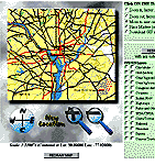
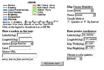
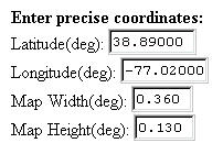
The Tiger Census (lat/lon) Map Server
The "link" below is an example of the relationship between GPS numbers (on the ground) and the census server map coordinates. Paul Charles Construction Company, McGregor, Texas 76657
Return to EARTHUSE Homepage All contents copyright (C) 1993-1999, D. Fehler All rights reserved. |