A Guide to the Theory and Application of Environmental
and Landuse Planning.
Homepage | Thematic
Maps | Proximity Maps
| Satellite maps
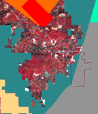
Multi Spectral Scanner (MSS) Image
 |
A great deal of
information is available from satellites circling the earth. The
data is effectively a digital image of the portion of the earth within
the study area. This portion of the database is available
to students that wish to develop their Image Processing skills. This
multi spectral, infra-red image shows forested areas in red. Developed
(urban) areas in pink, water (with suspended sediment) in light aqua, and
bare ground (and concrete) as white in color.
The area is equal to the Forest Hill, 7.5 minute quadmap.
Large map example |
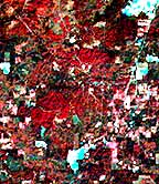
The satellite sensor(s) is tuned to the infra red spectrum,
meaning the green chlorophyl of plants is displayed as a red color in the
image. The white color is bare ground (quarries) and the blue green
color is often water. (some bare earth). You can see from the image
the study area is mostly tree covered.
The satellite data has been spatially corrected and will
register (overlay) with the entire Teaching Database.
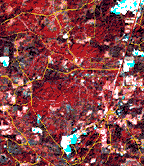
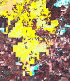
Here are some examples that "overlay" the Geographic
Information System (GIS) maps with the satellite image:
| Boundary
|
Roads
 |
|
Streams |
Soils
|
Teaching Database MSS
Image
A larger Area
View is available.
Return to Teaching Database Homepage
All contents copyright (C) 1992-1999,
D. Fehler and R. Robinson, All rights reserved.
|