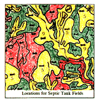
The Graphic Overlay Method

Combining Strategy
Homepage  |  Introduction  |  Map Features  |  Feature Measurements  |  Coding
Value Added Maps  |  Elevation Maps  |  Soil Survey Maps  |  Soil Attributes
Soil Characteristics  |  Combining Strategy  |  Process Map  |  Solution Map

Criteria is the driving force for which maps are selected, then combined.  The Selection Criteria is the "focus" of the landuse question and should be of single (or clear) purpose.   

Example of a Criteria Statement: 

Using the Graphic Overlay Method..., isolate all land that is above 150 feet in elevation, and has a "slight" risk (or better) for septic tank absorption fields. 

To solve the question, we need two maps.  (selected from previous examples) 
 

The Range of Elevations (below 150 feet in elevation) are "not" considered and are colored black. The green color isolates those soils that have "slight" restrictions for septic tank absorption fields.
Elevations of 150 feet and higher
Slight restrictions for septic tanks

Look at the Process for combining these two maps.  

Return to the Graphic Overlay Homepage


All contents copyright (C) 1993-1999,  D. Fehler  All rights reserved.