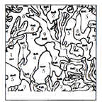
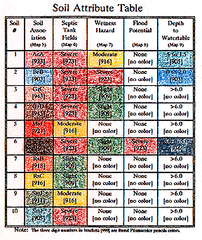
The Graphic Overlay Method

Soil Survey and Attribute Tables
Homepage  |  Introduction  |  Map Features  |  Feature Measurements  |  Coding
Value Added Maps  |  Elevation Maps  |  Soil Survey Maps  |  Soil Attributes
Soil Characteristics  |  Combining Strategy  |  Process Map  |  Solution Map

Value Added Soil Association Maps 

The U.S.D.A (SCS) Soil Surveys include many useful Soil Attribute Tables that can be directly organized and coded to reveal a number of important characteristics about the land in the area.  Example characteristics are color coded to demonstrate: 

  • Locations for Septic Tank Fields

  • Conditions are favorable for Septic Drain Fields 
  • Wetness Hazards

  • Soil moisture is retained longer in these areas. 
  • Flood Potential

  • Areas where flooding is possible (or probable). 
  • Depth to Water Table 

  • Depth to seasonally average ground water.
Soils with "like" characteristics are color coded for easy viewing.  The Soil Attribute Table (right) represents the coding table for the soil associations (soil names) and 4 of the many possible (value added) example maps.  

Each table "column" is a different, (unique)..., color coded map, where the colors (and soil characteristics) on the soil maps are coded to match the colors (and soil characteristics) in the soil table. 

One can quickly determine which areas are suitable for particular land uses.  For example, one can determine which areas to avoid building structures because the area is low lying and susceptible to flooding.

 
Note: The three digit numbers in brackets [999]
are Berol Prismacolor pencils colors.
Any number of maps may be created by this coding method.  Simply code the table and then color the area of the map containing your "study area." 


Look at the more detailed view of the Soil Characteristics Maps  
 
Return to the Graphic Overlay Homepage

All contents copyright (C) 1993-1999,  D. Fehler  All rights reserved.