Elevation Map Examples
Homepage | Introduction
| Map Features |
Feature Measurements |
Coding
Value Added Maps
| Elevation Maps | Soil Survey
Maps | Soil Attributes
Soil Characteristics
| Combining Strategy
| Process Map | Solution
Map
Topographic "elevation" maps describe the
relative height of land above mean sea level (msl). These maps (below)
represent an area of approximately 640 acres and are hand coded to emphasize
"specific features" (to be used in the coming examples).
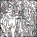 |
Uncolored topographic elevation.
These Topographic Map examples are small portions (Section
28) of the USGS Forest Hill, LA (1:24,000). |
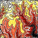 |
Topographic elevation colored according to the 10 foot
differences in elevation (above mean sea level).
The coding logic follows the scheme..., lighter colors
are the highest elevation and darker colors are the lowest elevation. |
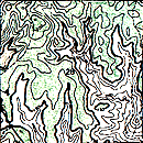 |
A green color is assigned to emphasize elevations above
150 feet msl. In the coming example, the example criteria requires
areas above 150 feet.
One way of emphasizing the land that is "needed" is to
remove (color black) the areas that do not fit the criteria, as in the
example below. |
 |
The color Black indicates areas that are not needed (desired)
for this particular example. Using the reverse logic..., "Black areas,
are areas you don't want" (The color black eliminates elevations
below 150 feet msl).
This map is used in the (coming) map combining example. |
The Soil Map
is the second Value Added example.
Return to the Graphic Overlay Homepage
All contents copyright (C)
1993-1999, D. Fehler All
rights reserved.
|