Introduction to Mapping
Homepage | Introduction
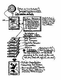
| Map Features |
Feature Measurements |
Coding
Value Added Maps
| Elevation Maps |
Soil Survey Maps | Soil
Attributes
Soil Characteristics
| Combining Strategy
| Process Map | Solution
Map
"Man is that uniquely conscious creature
who can perceive and express. He must become the steward of the biosphere.
To do this he must design with nature." (McHarg, 1969)
 |
In 1968 the landscape architect Ian McHarg published
the book "Design With Nature". It has become a standard for land planners
and managers because it considers the earth's natural and human systems
from the point of view of the landscape architect. Never before had the
complexities of the relationship of land use elements been combined graphically
to conclude proposed alternative locations of land and water activities.
McHarg's process was to create a spatially correct, graphic
model (of the existing conditions, opportunities, and constraints), test
alternative solutions, and determine what was thought to be the best possible
option. The case examples McHarg provided were arguments for the collection
of detailed information specifically pertinent to the needs of his clients. |
He developed a process that began with a knowledge of clients
needs and targeted the collection information toward that need. Mc
Harg's book is a guide and still a handbook for suggesting, and directing
the collection of composite map information.
Relevant Applications
The environmental books teach us the earth is a compound/complex
arrangement of physical, biological, and cultural components with an infinite
range of potential "so called" social and appropriate solutions. Many point
out that prime agricultural land and best forest land is vanishing at an
alarming rate in this country.
| Others are quick to point out not all land is suitable
for agriculture, and not all land is appropriate for housing development.
The question is how do communities determine the "best use"
or the appropriate "range of use possibilities" for any particular portion
of land. Whether good or bad..., all land, and the human use to which
it is put, is ever changing. |
 |
Pattern Interpretation
Activities and resources have been historically identified
by their distinct patterns. Human activities tend to be geometric patterns,
while natural resources patterns appear organic. Gaining experience with
natural system surface patterns and understanding the pattern contrast
of human activities will pay huge educational dividends to those that spend
the time investment.
Pattern cognition begins with a realization that there
is potential for: "The characteristics of mountains are often reflected
in the soils", or "Atoms behave at the molecular level predictably at the
scale of the universe". Natural systems and natural processes obey logical
patterns that are predictable. But, one must be sensitive to inconsistencies
such as:
1) Not all patterns reflect natural systems.
2) Some activities are not easily recognizable.
3) Patterns can yield incorrect assumptions.
4) Without pattern cognition GIS is only chaos.
5) Some patterns are only distractions.
Understanding the distributions, relationships, and organizations
of natural systems is integral in gaining the capability to "input" the
data of GIS, but not critical to understanding GIS application. Achieving
competence will require one to cultivate collateral skills and techniques
that, while not essential to learning GIS, is critical to GIS proficiency
related to environmental issues.
Developing and using "your best judgment."
With any given location within a community there are positive
qualities and negative qualities. The positive qualities are the
opportunities (for building houses, creating wetlands, building roads,
etc.). The negative qualities are the constraints (like too many
rocks to farm the land, to wet to grow pine trees for lumber, too steep
for a safe road, etc).
 |
We all want our local areas and neighborhoods to enjoy
the "best" possible land (and water) uses that, (during construction and
years after), will have the least environment impact and seriously attempt
to maintain (or enhance) the character to the community.
Before recommending a particular land use, as local citizens
we should all ask several fundamental questions:
Are we developing the collective conditions that are best
for this landscape? Before any construction ask: can I technically
do what is proposed for this portion of land? More often we could
ask: "should I change this land from its current use?" |
Typical questions that could be answered
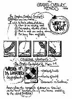
using the Graphic Overlay Method of GIS:
-
Will this soil support the proposed building foundation?
-
Does this property flood.., will it damage my building?
-
Will agricultural crops grow well here?
-
Will my road be too steep for trucks?
-
Will the landfill contaminate the ground water?
-
Is this a dangerous area for landslides?
-
Is this the best location for my new orchard?
-
What and where are wetlands?
-
What and where are agricultural lands?
-
What agricultural lands are most/least productive?
-
What and where are forest lands?
-
What forest lands are most/least productive?
-
Where will the new highway be best located?
-
Where will the new airport be best located?
-
Where is the best wildlife habitat?
-
Where are the best locations for new industry?
-
Where is the best location for the new vacation resort?
Look at the Map
Features page.
Return to the Graphic Overlay Homepage
All contents copyright (C)
1993-1999, D. Fehler All
rights reserved.
|